? ??????????????????? ????Easy Install Instructions:???1. Copy the Code??2. Log in to your Blogger account
and go to "Manage Layout" from the Blogger Dashboard??3. Click on the "Edit HTML" tab.??4. Delete the code already in the "Edit Template" box and paste the new code in.??5. Click "S BLOGGER TEMPLATES AND TWITTER BACKGROUNDS ?

Saturday, August 29, 2009

OLYMPIC NATIONAL PARK
If you are anywhere near this wonderful park, please make plans to see it.  There is so much to see and do here.  We spent several different days going to different parts of the park but there is still so much that we did not have time to do.  I hope you enjoy the pictures!
Hurricane Ridge, probably the most popular viewing spot in the park.
Somehow, Doug talked me into taking a one lane (with two way traffic) road from Hurricane Ridge up the side of the mountain to a place called Obstruction Pass, elevation 6100 ft.  I do not have Doug's confidence about driving roads with sheer drop offs and no guard rails!!  I don't have any pictures of the sheer drop offs because I had to close my eyes and pray!
This is the pass, but we did not hike to the summit.  Wow, you can sure see a lot from up here!
Next, we went to the Lake Crescent area of the park and hiked through an old growth forest to Marymere Falls.  Below is a picture of the trail.  As you can see some of the trees are just HUGE.  Yes, that is us standing at the base of the tree.  You couldn't tilt your head back enough to see the top of the tree.  You would have had to lie down on the ground and look up (we didn't try this but I think it would work).
This is the root ball of a tree that had toppled over in the forest.  Doug estimated that the diameter was around 15 ft. WOW!
Marymere Falls
The falls drop 90 ft. from the top into a gorgeous pool
Sol Duc Region and falls
The drop on these falls is not nearly as great as Marymere, but they are unique because there are 3 falls coming from the same water source above.  You can see the depth of the canyon if you look at the bridge at the top of the photo.  We have a 4 (almost 5) year old granddaughter who loves waterfalls; we took this one just for her.
This is Salmon Cascade, where the mature Salmon come in their quest to return to where they were born.  We could see them swimming in the water below the falls and occasionally they would jump out of the water.  It is just an accident if you get a picture of them jumping because they are up and down before you can snap a shot.  Doug saw one jump from the pool up into the swirling water around the rocks, but we never saw one get all the way to the top.  I am told that they will jump until they either make it or fatally injure themselves while trying.
Well, I hate to end on that note about the Salmon fatally injuring themselves, so I found another picture you may enjoy of the fabulous Olympic mountain range.  This is a close up from Hurricane Ridge.

Sunday, August 23, 2009

Mt. Baker and Shuksan

It was not a perfectly clear day, but at least we could see the mountains.  The first picture is of the road we drove to get there, very twisty.


This is Mt. Shuksan from across Picture Lake in the Cascade mountain range

This is called Artist Point - lots of pictures taken here
Not much to say about these except WOW!!
This is Mt. Baker

Friday, August 21, 2009

Our Week in Anacortes, WA

We are over in the Olympic Peninsula now but I wanted to share what a wonderful week we had last week. First of all, after camping in the national forests for a week we enjoyed our stay in a commercial campground in Anacortes with cable TV (the first time we had seen the news since mid June). It was also nice to have full hook-ups (no need to ration water) and had easy access to stores, etc. We also went out to eat a few times, something we have done very little of in the past 2 months. I guess we'll have to scratch this weeks "weigh day"!

Anacortes has a population of about 17,000, so it's not too big or too small. It has access to beaches, mountains and nearby islands as well as Canada. There are ferry boats that take you to the San Juan Islands and to Victoria Island in Canada. You can actually see snow capped Mt. Baker from the marina in downtown Anacortes!
Here are some of the highlights of our week
This was taken at Mr. Erie Park's 1,270 peak. When it is not a hazy day you can see much farther. This is Doug at Mt. Erie. You may not have seen him since he had a buzz cut. He also looks different because he has lost 18 lbs. since he had the stent put in his heart in June. The doctor told him to lose 30 lbs. so he is trying. Good job, Doug!
The Deception Pass Bridge connects Fidalgo Island (where Anacortes is) and Whidbey Island (where the Naval Air Station is). The bridge and pass are very scenic and very popular.
We took a hike around this area. Doug is sitting on a tree on the hiking trail that has been bent over. You can see a lot of trees that are bent like this, primarily due to the weight of the snow in the winter, and yet they still survive and thrive. It kind of reminded me of the weight of trials in our lives sometimes, yet Jesus carries us through them and we become stronger.


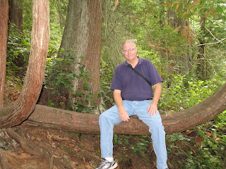
Looking toward the San Juan Islands from a hiking trail at Deception Pass.


Views from the Deception Pass bridge


This is only about half of what we did while in Anacortes. Some of the prettiest pictures are yet to come, but I'll have to work on that tomorrow. Thanks for keeping up with what we are doing. I hope you're having a very blessed summer!

Friday, August 14, 2009

Hello, Northern Washington

We finished the Selkirk Loop and have driven all the way across northern Washington state on state highway 20. We are now in Anacortes, Washington which is about 2 hr. north of Seattle. We took about 5 days to drive here from Idaho and stayed at National Forest campgrounds during that time. One of the campgrounds was in a canyon with no cell or internet. Even the camp hosts only had a two-way radio for emergencies. It felt pretty strange not to have cell or internet service at all, but it was quite a scenic drive and very little traffic.
Here is a picture of Doug at one of the Forest Service campsites in the North Cascades.

One of the mountain passes we went through was Washington Pass (elevation 5500 ft). Believe it or not, the road was really pretty good and we had no problems. At the summit there is an overlook and even the trail out to it was gorgeous. The overlook is where we took the pictures.


All the lakes here are pretty, but it is hard to beat a lake called Diablo Lake. It is on a stretch of Hwy. 20 in North Cascades National Park that is closed in the winter. As you can see, the color of the water is almost emerald green. That is because as glaciers in the high country slowly wear down the mountains, the grinding of rock against rock produces a fine silt that is carried into the lake below. This “rock flour” suspended in the water reacts with light to give the lake its blue-green color. The bottom picture shows it best, although it is even more vibrant when you see it in person. The variety of scenery that God placed on this earth is just amazing! That we would be blessed enough to travel and see it this summer is also amazing. God is so good to us!


Saturday, August 8, 2009

Goodbye, Idaho…

After having so much fun in Idaho in July, we have moved on to the Canadian portion of the Selkirk Loop and then into Washington state. We made a couple of side trips before we left Idaho and one was to a large lake near Sandpoint, Idaho. The name of the lake is Priest Lake. We ate lunch at a nice resort there and then took a hike to Cedar Falls at Roosevelt Point. The falls were nice, but the most amazing thing was the HUGE cedar trees.


One of the last things we did before we left Sandpoint, Idaho was to attend the annual Huckleberry Festival at Mt. Schweitzer. This included all things huckleberry, and I mean all things; nothing is too much for a berry that is the state fruit (do all states have a state fruit?). They had jam, huckleberry honey, pancakes, syrup, cakes and pies just to mention a few. Then if you wanted to you could tie die a t-shirt using huckleberry juice and other colors (that was a popular activities with the kids). Last, but not least, guess what they had! Yep, you were right; huckleberry ice cream! Vicki surely was glad to get one more chance to eat her new favorite dessert (other than chocolate, of course).

Mt. Schweitzer is a small but quaint ski resort. The pictures are a bit hazy. Actually we have been told there is a forest fire somewhere in British Columbia that is blowing smoke down this
way, so things are hazy almost everywhere
right now.
The day after the festival we left for Canada. We only spent 2 days there on the Selkirk Loop but really enjoyed ourselves. In case you aren’t familiar with the Loop, it is a 280 mile loop that includes northern Idaho, British Columbia and Washington. It is well worth visiting. At the very top of the loop in BC, you must take a ferry across Kootenay Lake. People drive their cars or motorhomes onto the ferry and in about 45 minutes you are at the other side of the lake.
Right now we are on our way toward northwestern Washington. We will make a few stops along the way and then spend 7-10 days in Olympic National Park. There is plenty of pretty scenery along the way, especially as we travel through North Cascades National Park.

Saturday, August 1, 2009

A special town...McCall, Idaho

After we left the Sawtooth region of Idaho around Stanley and Challis, we decided to head north toward the Coeur d’Alene area. We decided to stay in an Idaho state park and picked a town called McCall that is on Payette Lake. We were only going to stay 2 nights and then head further north. On the way into McCall, our brakes began to have a grinding sound. We had had them checked before we left AR so we didn’t think too much about it. We called our roadside assistance program and they located a place in McCall for us to have them checked. As it turned out, we had to have some repairs done that required parts to be ordered and they couldn’t schedule the work to be done until they had the parts there (you know how these stories go, right?). So, we ended up staying 6 days; not what we had planned but we ended up loving the town of McCall and the park there. The park is the Ponderosa State Park and is one of the nicest places we have ever stayed. There were hiking and biking trails, overlooks and miles of roads within the park to wall.


While we were there we also went over to the Hell’s Canyon Scenic Byway since we had never been there. The view of the Canyon with the mighty Snake River was impressive as you can see.
McCall is a fairly small resort town. In the summer it has much cooler temperatures that Boise, which is 2 hours to the south, so the weekends especially are busy there. In winter they have a ski resort, not large but nice. We were able to drive to the top of the mountain one day and you can see the valley below – very nice.


We also had some time to take care of some routine chores (yes, there are still plenty of chores to do even though we are not at home – fun things like going to a laundromat, cleaning the motorhome and buying groceries). Another thing we discovered is huckleberry picking. Late July and August is the time for huckleberries in Idaho (by the way, they are the state fruit). They grow wild and were everywhere is the park, so everyone just gets a container and picks away. I didn’t know what a huckleberry was, but they look a lot like a blueberry, but are smaller and sweeter. They make huckleberries into everything – ice cream (very yummy), pancakes, milkshakes and pies (also yummy). Believe it or not they sell for $25-40 per gallon on the side of the road, which is the only way you can get them. I have really grown to love the huckleberry ice cream, but it has not helped me lose any weight (imagine that!).
If you ever have a chance to go to Idaho, we highly recommend McCall and Ponderosa State Park. Now, our travels are taking us to the Idaho Panhandle where we will take the Selkirk Loop and then head into Washington. More pictures to come.